Do you know what the soil is like in the area of ABC Street at XYZ Street? Do you know where the water table is there? Can you get to 30 feet at this site with a small drill?
These are typical questions we get when receiving drilling inquiries. The publicly available Ontario Water Well Records database can be a good source of information that is very popular with consultants.
If you plan to drill there, we may have drilled in that area in the past, maybe even at your site. When we complete a drilling project, we complete a Drilling Report, which contains basic site information, hours, supplies and a description of our work on that project. Over the last 28 years, we have accumulated thousands of these reports, all containing valuable information regarding our work at the sites. This information includes but is not limited to, drilling depths, the type of drill used, and sampling depths. Some reports include soil types, water levels, and even bedrock depths.
We realize that the data in these reports can be beneficial in answering some of the questions mentioned above. Therefore, we figured out a way to access the information contained in the paper reports. We have spent several years and dedicated hundreds of person-hours working on this project. Pertinent information has been input into a geocoded database system, with mapping functionality, based on each of our Drilling Reports dating back to 1994.
Below is a screenshot of a map area, with each green dot representing a Kodiak drilling site. When we click on the dot, basic site information about our work at the location is displayed. Using the references, we can also look up the paper version of the drilling report for even more information. You don’t need to worry about the confidentiality of your data in our files, as we do not disclose the names of our clients when discussing these sites.

This is a screenshot of an area; green dots represent past Kodiak drilling locations. Clicking on the dot gives us site details.
After we completed this project, we decided to take it one step further. We overlaid the Ontario Geotechnical Borehole Database into our system. See below a screenshot of the same area with these boreholes now shown (in red). Also, note that the image on the right depicts a typical entry from one of those borehole locations.
If you would like more information about your area, please give us a call, and we can look up your site address and offer feedback.
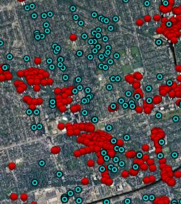
This screenshot overlays the Ontario Geotechnical Database (red) with the Kodiak locations (green).

Clicking on the red symbols gives us these pop-up bubbles with the site information in the Ontario database.